


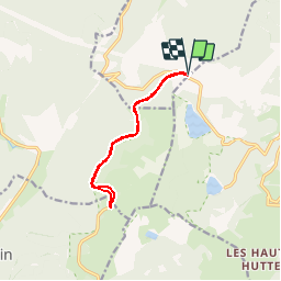
Col du Calvaire-route des crêtes

ZAMBAUX
User

Length
9.7 km

Max alt
1229 m

Uphill gradient
132 m
Km-Effort
11.4 km

Min alt
1147 m

Downhill gradient
131 m
Boucle
Yes
Creation date :
2019-04-27 09:34:18.393
Updated on :
2019-04-27 09:34:18.425
2h30
Difficulty : Very easy

FREE GPS app for hiking
 SityTrail
IGN / Geographical institutes
SityTrail Plus
The world is yours!
About
Trail Walking of 9.7 km to be discovered at Grand Est, Haut-Rhin, Le Bonhomme. This trail is proposed by ZAMBAUX.
Positioning
Country:
France
Region :
Grand Est
Department/Province :
Haut-Rhin
Municipality :
Le Bonhomme
Location:
Unknown
Start:(Dec)
Start:(UTM)
357809 ; 5333225 (32U) N.
Comments